About
Cultural Resource Management Services
The Archaeological Survey performs a broad array of cultural resource management services for a diverse array of clients and agencies. Contact us for a proposal.
Phase 1A Background Research and Sensitivity Estimates: Phase 1A projects represent background research including historic documentary research and historic map analysis, as well as UB and State Historic Preservation Office site file research. The purpose of most Phase 1A surveys is to establish the presence of known or likely archaeological sites and historic resources over 50 years of age within a given project impact area. Another goal is developing historic and prehistoric contexts as a preliminary step prior to Phase 1B fieldwork. Most Phase 1A and Phas1B projects are done together as a single endeavor.
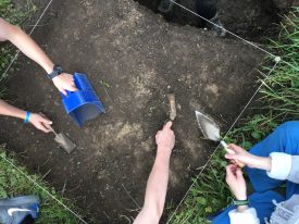
Phase 1B Archaeological Reconnaissance Surveys: Phase 1B archaeological surveys typically involve reconnaissance level fieldwork to determine whether archaeological sites or other cultural resources are present in a given project area.
Phase 1B Architectural Reconnaissance Surveys: Phase 1B architectural surveys typically involve reconnaissance level fieldwork to determine whether buildings, structures, monuments and other elements of the built environment in a project area are potentially significant cultural resources eligible for the National Register of Historic Places.
Phase 2 Site Examinations: The Goal of Phase 2 Site Examination is to determine whether archaeological sites and other cultural resources are eligible for the National Register of Historic Places, and thereby worthy of avoidance or subsequent data recovery in a development context.
Phase 3 Data Recovery: The Goal of Phase 3 Data Recovery is to collect significant data from National register eligible archaeological sites and other cultural resources that cannot be avoided and therefore will be impacted by a proposed development.
Historic American Building Survey (HABS) and Historic American Engineering Record (HAER): The Historic American Buildings Survey/Historic American Engineering Record (HABS/HAER) is a division of the National Park Service responsible for documenting the historic buildings, sites, structures, and objects of this country by producing measured drawings, large format photographs, and written histories. The Library of Congress Prints and Photographs Division is the repository for these documents. The American Institute of Architects, the American Society of Civil Engineers, and the other founding engineering societies provide technical guidance. The regional offices of the National Park Service in Philadelphia, Atlanta, Denver, San Francisco, and Anchorage administer the mitigation documentation program. The Survey has performed several such projects in western New York, typically for bridges and other structures spanning historic waterways and scenic byways including the Erie Barge Canal and US Route 219.
Technical Issues
All work is performed on behalf of clients in consultation with the New York State Office of Parks, Recreation and Historic Preservation (OPRHP/SHPO). Implementation of the statewide highway archaeology program necessitates work in cooperation with, and to the standards of the New York State Education Department (SED) and New York State Museum (NYSM). We also regularly interact with and perform projects to standards that meet or exceed those of the US Army Corps of Engineers and New York State Department of Environmental Conservation (DEC).